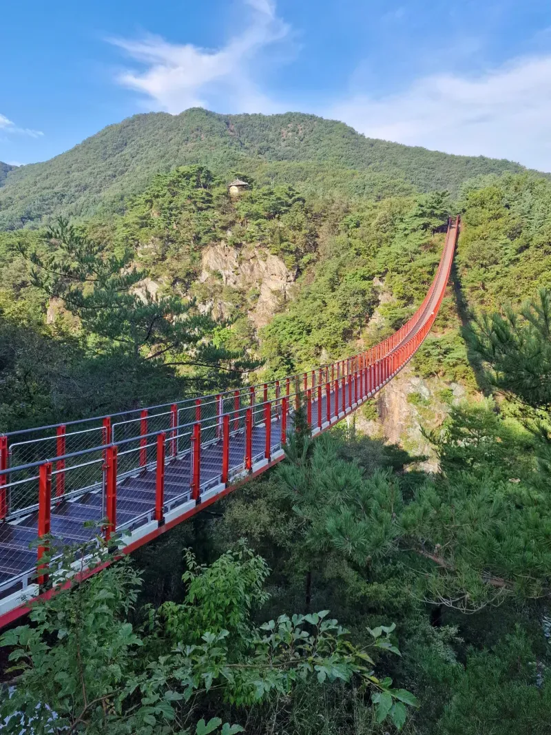
About All Tours DMZ & JSA ToursHalf Day ToursPrivate ToursGamaksan Suspension BridgeThird Tunnel Tours Directions Hours & Fees
Find Tours 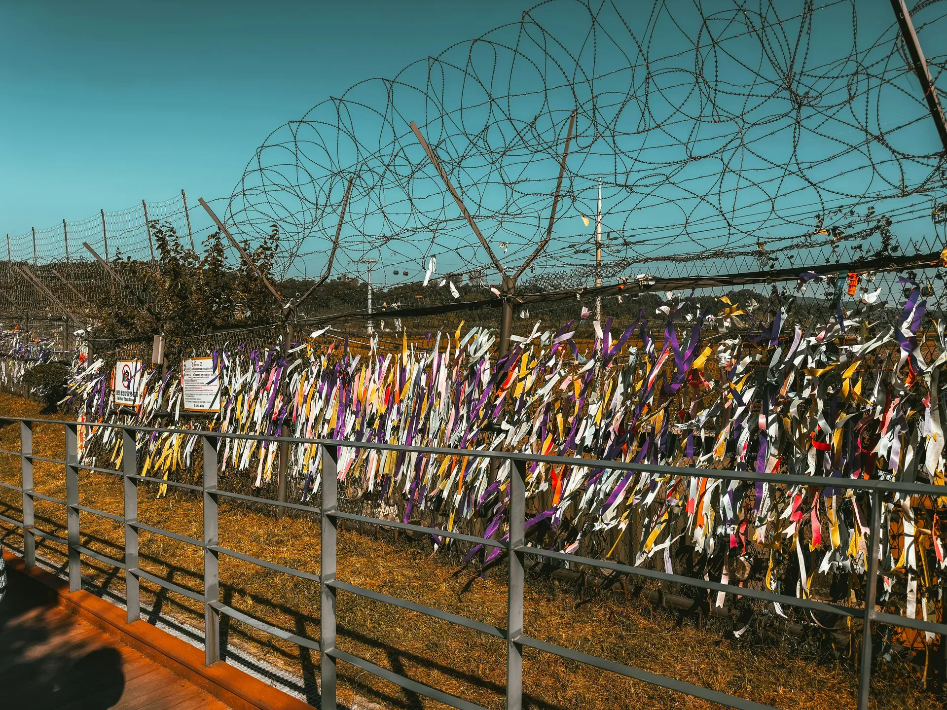
The Korean Demilitarized Zone cuts a 248-kilometer line across the 38th parallel, dividing the peninsula with landmines, barbed wire, and military personnel. It stands as the last remaining frontier of the Cold War and the most heavily fortified border on earth.
Two million landmines litter the 248-kilometer stretch of land dividing the Korean peninsula. Barbed wire fences, tank traps, and armed guard posts trace the 38th parallel from the Yellow Sea in the west to the Sea of Japan in the east. This 4-kilometer-wide strip of territory separates North and South Korea, enforcing a ceasefire signed in 1953. Human habitation stopped entirely within these borders seven decades ago. Without agricultural or industrial interference, the zone transformed into an accidental ecological sanctuary. Endangered red-crowned cranes, Amur leopards, and Asiatic black bears roam freely among rusting anti-tank barricades and overgrown minefields.
Visitors travel 52 kilometers north from Seoul to witness this ongoing military standoff. The journey follows the Han River, where the northern banks bristle with razor wire and military watchtowers. Military escorts guide civilians through strict checkpoints into the Joint Security Area (JSA), an 800-meter wide enclave at Panmunjom. Here, soldiers from both nations stand mere meters apart, locked in a perpetual staring contest across a concrete slab that marks the Military Demarcation Line. Security conditions dictate daily access. Sudden diplomatic tensions or unannounced military drills frequently cancel tours without notice. Check the United Nations Command official notices before departing Seoul.
Beyond the surface fortifications, a subterranean frontline exists. North Korea dug multiple invasion routes under the border during the 1970s. The 3rd Infiltration Tunnel, discovered in 1978, sits 73 meters underground and stretches 1,635 meters through solid bedrock. Tourists walk down a steep 11-degree incline into the damp, narrow shaft. The ceiling drops low enough that hardhats frequently scrape the jagged rock. At the end of the accessible route, three thick concrete barricades block the path to the North. Bring your physical passport, as digital copies hold no weight at the military checkpoints.
The civilian control zone surrounding the DMZ adds another layer of security. Visitors cannot explore freely. You must board authorized tour buses at Imjingak Park or join organized groups from Seoul. The buses navigate narrow roads flanked by red triangular signs warning of active minefields. The atmosphere shifts noticeably as you cross the Civilian Control Line. Military police board the buses to inspect identification documents. The tension is palpable, a stark reminder that the Korean War merely paused and never officially ended.
The sheer scale of the military presence becomes apparent long before you reach the border. Anti-tank barricades disguised as highway overpasses span the main roads leading north, wired with explosives to drop massive concrete blocks and halt an armored advance. The riverbanks feature miles of tall fencing topped with razor wire, illuminated by floodlights every night. This infrastructure exists for one reason: delaying a potential invasion long enough for allied forces to mobilize.
The Korean Armistice Agreement halted combat operations on July 27, 1953, after three years of devastating warfare. Military commanders drew a line across the peninsula based on the final frontlines, forcing both armies to pull back two kilometers. This created a 4-kilometer-wide buffer zone stretching 248 kilometers coast to coast. The agreement established the Joint Security Area at Panmunjom as a neutral meeting ground. Initially, soldiers from the United Nations Command and the Korean People's Army shared the space, moving freely across the compound. Tensions erupted violently on August 18, 1976, during the Axe Murder Incident. North Korean forces attacked and killed two US Army officers attempting to prune a poplar tree that blocked the view between allied checkpoints. The event prompted Operation Paul Bunyan, a massive show of force, and resulted in the immediate physical division of the JSA. A concrete line was poured, and neither side could cross it again.
Defectors warned South Korean intelligence about subterranean activity throughout the 1970s. Engineers detected underground explosions and eventually intercepted a water-filled shaft on October 17, 1978. They uncovered the 3rd Infiltration Tunnel just 52 kilometers from Seoul. North Korean forces had painted the granite walls black with coal dust, falsely claiming it was an abandoned coal mine despite the geological impossibility of coal forming in that specific rock layer. The tunnel's dimensions allowed 30,000 heavily armed troops to pass through per hour, positioning them to launch a surprise attack on the South Korean capital. South Korea subsequently discovered three other tunnels along the border and maintains sophisticated listening posts to detect any further digging operations.
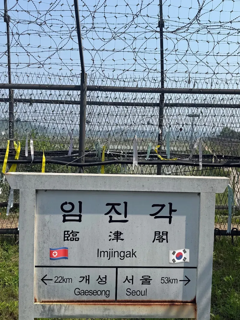
The border saw moments of diplomatic progress amid the decades of hostility. The 2018 Inter-Korean Summit brought leaders from both nations together at the JSA. They shook hands across the concrete demarcation line and briefly stepped into each other's territory. This summit resulted in temporary demining operations and the removal of several front-line guard posts. Civilian access fluctuates heavily with the political climate. The DMZ Peace Link Train resumed service on April 10, 2026, after a 6.5-year hiatus caused by a combination of swine fever outbreaks, a global pandemic, and deteriorating relations. It runs four times a month from Seoul Station to Dorasan Station, the northernmost railway stop in South Korea. Dorasan sits fully equipped with modern customs and immigration facilities, waiting for a connection to the Trans-Siberian Railway that currently leads nowhere.
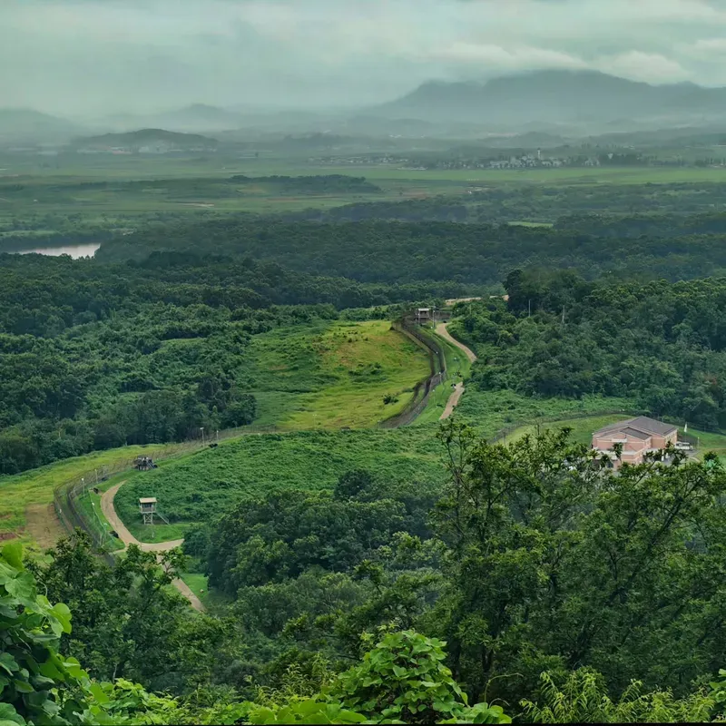
The 248-kilometer border crosses dense mountains, coastal swamps, and the fast-flowing Imjin River. High-tensile barbed wire runs the entire length of the southern boundary, interspersed with concrete guard posts, thermal cameras, and electronic surveillance sensors. The natural terrain dictates the military architecture. In the mountainous eastern sector, observation posts sit on high ridges overlooking steep, heavily forested valleys. The western sector features flatter ground, making it the historical invasion route and the current site of the heaviest fortifications. Landmines saturate the soil in unpredictable patterns. Military engineers estimate millions of unexploded ordnance remain buried in the 4-kilometer-wide strip, shifting with annual monsoon floods and making the ground permanently hazardous.
The 3rd Infiltration Tunnel cuts directly through solid granite bedrock. The shaft measures roughly 2 meters wide and 2 meters high, plunging 73 meters below the surface. Groundwater constantly seeps through the porous rock, requiring industrial pumps to prevent the passage from flooding. The air inside stays cold and damp year-round, hovering around 15 degrees Celsius. Visitors descend via a steep, 350-meter interception tunnel built by South Korea to intersect the North Korean passage. Yellow hardhats protect heads from jagged rock outcroppings along the low ceiling. The physical toll of the walk is significant. The 11-degree incline on the return trip tests the stamina of most visitors. The tunnel is not recommended for those with claustrophobia or heart conditions.
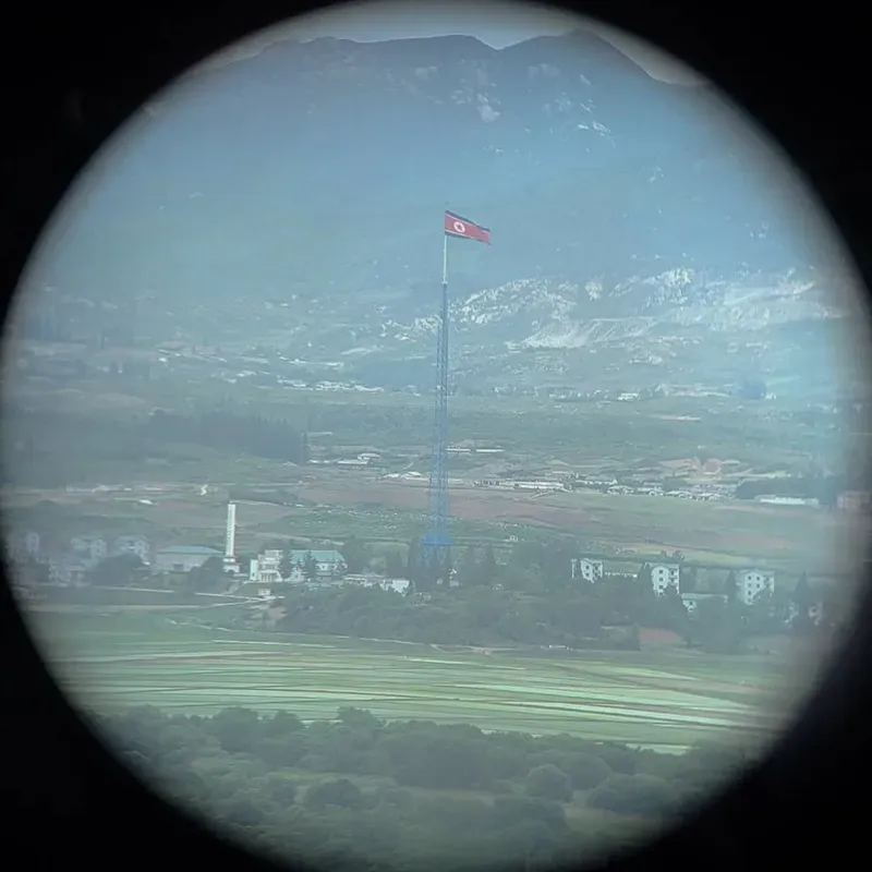
Above ground, Dora Observatory sits on the peak of Mount Dora, offering a sweeping vantage point over the demilitarized zone. High-powered binoculars line the outdoor viewing deck. On clear days between September and November, the lenses reveal the North Korean city of Gaeseong, the country's third-largest metropolis. You can clearly see the Kijong-dong propaganda village, built in the 1950s to project an image of economic success. A 160-meter flagpole towers over Kijong-dong, flying a massive 270-kilogram North Korean flag. The village features brightly painted multi-story buildings, but telescopic observation reveals they lack window glass and interior rooms. Heavy monsoon rains in July and August frequently drop visibility to zero. Check the morning weather forecast before buying a ticket.
Families torn apart by the 1953 armistice gather at Imjingak Park during major lunar holidays like Chuseok and Seollal. They perform traditional ancestral rites at the Mangbaedan Altar, bowing toward hometowns in the North they cannot visit. The park's chain-link fences carry thousands of brightly colored ribbons tied by citizens over the decades. Each ribbon bears handwritten messages hoping for reunification or mourning lost relatives. The Freedom Bridge stands nearby, an original structure from the war's end. Nearly 13,000 prisoners of war walked across its wooden planks to return to South Korea after the ceasefire. The bridge now dead-ends at a barricade, standing as a stark monument to the divided peninsula.
The border zone sustains a small, heavily monitored civilian population. Unification Village (Tongil Chon) sits within the restricted civilian control area, housing about 400 residents. These farmers cultivate high-quality soybeans and ginseng under strict military curfews. They undergo daily identity checks at military checkpoints and cannot leave their homes or work in the fields after dark. Their presence maintains South Korea's civilian footprint in the buffer zone, a direct counter to North Korea's Kijong-dong village across the border. Visitors on authorized tours can purchase local agricultural products at the village store, directly supporting the community living on the frontline.
Camp Greaves, a former US military base near the Imjin River, now operates as a youth hostel and arts center. Visitors ride the DMZ Peace Gondola across the water to reach the compound, which housed the 506th US Infantry Regiment for fifty years. The original bowling alley, ammunition bunkers, and officer quarters remain intact. The local government repurposed these military structures to display contemporary art installations dealing with division, trauma, and conflict. The site forces visitors to confront the physical reality of a war that shaped modern Korean identity. The juxtaposition of military architecture and civilian art highlights the ongoing psychological toll of the 248-kilometer barrier.
The demilitarized zone also permeates South Korean pop culture and literature. It provides the backdrop for blockbuster films and television dramas that explore the complex relationship between the two Koreas. These fictional narratives often highlight the shared language and heritage that persist despite the physical barrier. For younger generations with no direct memory of the war, these stories provide a crucial link to understanding the emotional weight of the border.
The lack of human development created a wildlife sanctuary hosting endangered Asiatic black bears.
Dorasan Station features international customs desks and signs pointing to Pyeongyang, despite no trains crossing the border.
North Korea erected a 160-meter flagpole in Kijong-dong to outdo a 98-meter flagpole built by South Korea.
North Korean soldiers painted the granite walls of the 3rd Tunnel with coal dust to disguise it as a coal mine.
The Joint Security Area spans exactly 800 meters in diameter, functioning as a neutral meeting ground for both militaries.
Visitors to the JSA cannot wear ripped jeans, camouflage, or sandals due to strict military dress codes.
Pointing a camera toward certain southern military installations from the observatories constitutes a criminal offense.
Yes, over 1.2 million tourists visit annually. Military escorts supervise all movements, and visitors remain in heavily secured, designated areas.
No. Access to the 3rd Tunnel, Dora Observatory, and the Joint Security Area requires an official guided tour. Independent travel into the restricted civilian control zone is prohibited.
A valid physical passport is mandatory for all foreign visitors. Military personnel check IDs at multiple checkpoints, and digital copies or photos are not accepted.
The border zone sits approximately 52 kilometers (32 miles) north of central Seoul. Organized tour buses typically make the drive in about one hour.
JSA access fluctuates based on diplomatic tensions. As of April 2026, tours are frequently suspended. Always check the United Nations Command official notices for current status.
Yes. High-powered binoculars at Dora Observatory allow visitors to see North Korean soldiers on patrol and farmers working in the fields around Kijong-dong village.
The Joint Security Area enforces a strict dress code prohibiting ripped jeans, camouflage, sleeveless shirts, and sandals. General areas like the 3rd Tunnel and observatories allow casual dress.
Photography is permitted from designated photo lines at Dora Observatory and specific spots in the JSA. Taking pictures of South Korean military installations is strictly forbidden.
The tunnel sits 73 meters underground. Visitors walk down a steep 11-degree incline to reach the 1,635-meter-long shaft carved through solid granite.
April to June and September to November offer mild weather and clear skies. Heavy monsoon rains in July and August severely reduce visibility at the observatories.
Browse verified tours with free cancellation and instant confirmation.
Find Tours